SERANG, Banten — The most consequential policy question after Anak Krakatau’s 25-hour eruptive episode is not whether one agency can issue a warning. It is whether volcanic, aviation, maritime and local-government decisions can move together quickly enough for people living and working around the Sunda Strait.
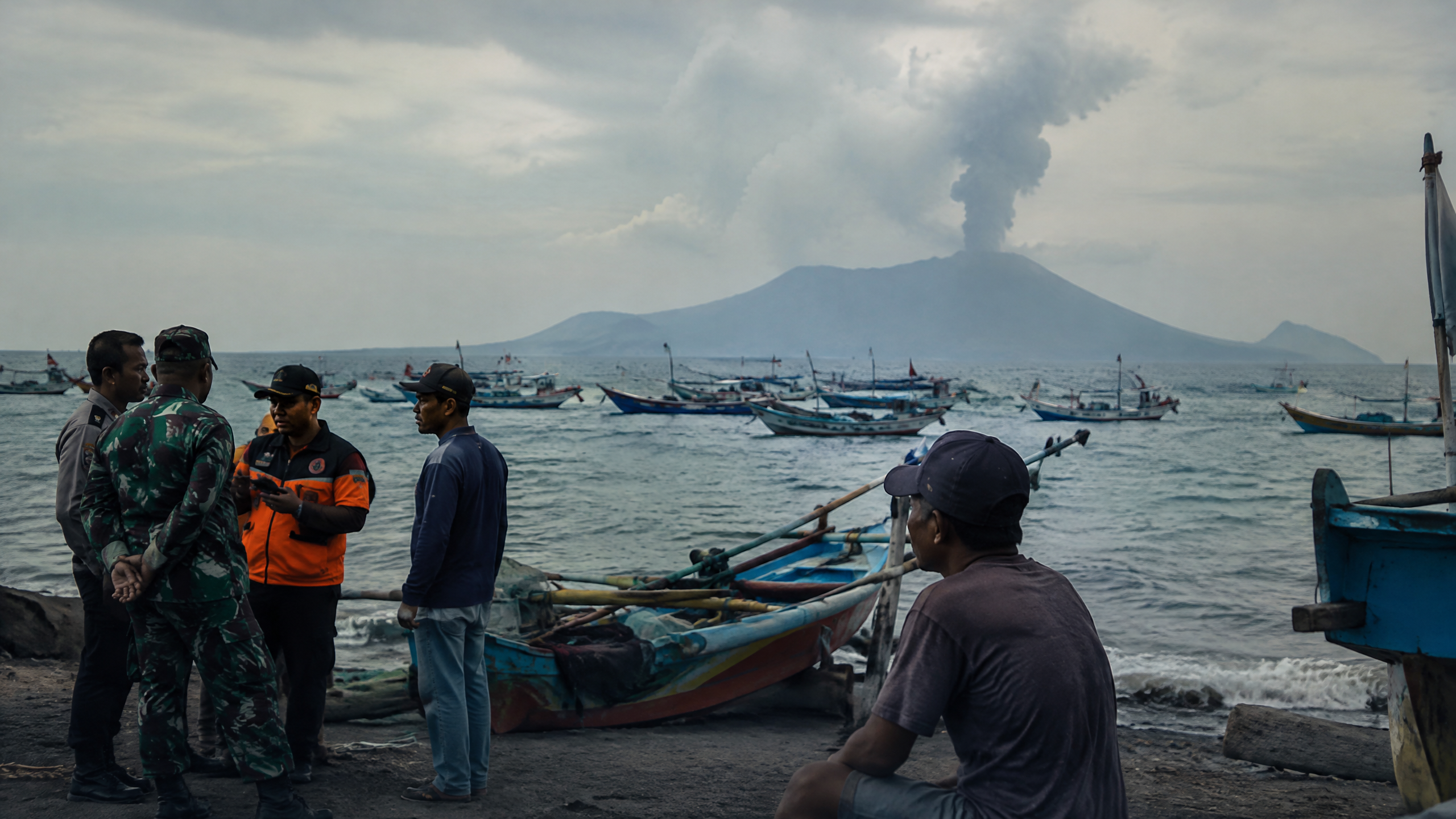
The episode began at 23:07 WIB on Sept. 4 and ended at 00:04 WIB on Sept. 6, according to the Center for Volcanology and Geological Hazard Mitigation (PVMBG), part of the Energy and Mineral Resources Ministry. A further Strombolian eruption was recorded at 03:53 WIB on Sept. 6. By Sept. 7, PVMBG said three Strombolian eruptions had followed the sustained episode, while the volcano’s alert remained Level III, or Siaga.
That status matters for Banten even though Anak Krakatau is administratively in South Lampung. The official geological report identifies observation posts in Kalianda, Lampung, and Pasauran, Serang Regency, Banten. The arrangement makes the Sunda Strait a shared operating space: information may originate at a volcano post in one province, while ash, flight disruption, sea activity and public anxiety are felt in another.
One ash cloud, several decisions
BMKG’s Sept. 6 briefing shows how quickly the event crossed institutional boundaries. Satellite analysis identified two ash-dispersion clusters extending across Banten, Jakarta, West Java and as far as Bengkulu. Ash was tracked at up to 20,000 feet toward the east and up to 50,000 feet toward the west.
At Soekarno-Hatta’s meteorological station in Tangerang, BMKG issued its first Significant Meteorological Information notice shortly after the initial eruption. By the agency’s account, 18 SIGMETs were issued in sequence. Those aviation warnings fed into decisions by the airport authority, AirNav Indonesia, airport operators, local authorities and the military. BMKG said temporary operational closures were recorded at Soekarno-Hatta, Halim Perdanakusuma, Radin Inten II and Budiarto at different times; the BBC, citing the Transport Ministry, reported that eight airports were temporarily suspended and 1,558 flights delayed, affecting about 170,000 passengers.
The policy lesson is practical: reopening an airport cannot be treated as a separate communications event from a change in ash dispersion. NOTAMs, SIGMETs, volcanic-ash advisories and airport decisions need to be legible to airlines, passengers and local governments at the same time. The Transport Ministry’s call for airlines to process refunds and provide timely information also shows that passenger protection becomes part of disaster policy once an eruption reaches the air-transport network.
Coastal calm must be evidence-based
For communities along Banten’s coast, the central challenge is communicating caution without creating an unsupported tsunami alarm. PVMBG’s Sept. 5 report said the rebuilt body of Anak Krakatau remained relatively small and, on the available assessment, did not have the potential to collapse at a scale capable of triggering a tsunami. On Sept. 6, BMKG reported that 20 tsunami gauges around the Sunda Strait showed no sea-level anomaly, while HF radar at Carita and Tanjung Lesung placed the tsunami probability at below 40 percent at that time and recorded waves of about one metre.
Those findings did not remove the need for vigilance. PVMBG kept the Level III status, barred people from entering within three kilometres of the activity centre and warned of incandescent-rock ejections, heavy ashfall and possible lava flows if sustained activity returned. It also told people on the Banten and Lampung coasts to remain calm, reject hoaxes and follow local disaster-management agency directions.
That instruction puts a premium on the role of BPBD offices and village-level communicators. Residents, fishermen and tourism operators need a clear distinction between three different messages: a volcanic exclusion zone around the cone; an ash and respiratory-health advisory; and a tsunami warning, which must be based on sea-level and geophysical evidence. Mixing those categories can either provoke unnecessary panic or encourage dangerous complacency.
SAR operations show why coordination cannot stop at the shoreline
A Sept. 15 Antara report from Pandeglang illustrates the operational problem. During a search involving Basarnas and other combined SAR elements, the Banten SAR office said Anak Krakatau’s activity was a specific safety consideration. The team aligned its movement with PVMBG’s periodic recommendations and used BMKG weather data, including reported wave heights of 0.5 to 2.5 metres and winds of 5 to 20 knots, to plan maritime operations.
That is the kind of cross-agency practice a post-eruption policy should formalise rather than leave to ad hoc briefings: PVMBG for volcanic hazards, BMKG for ash, weather and sea monitoring, AirNav and airport authorities for airspace, Basarnas for life-saving operations, and Banten’s BPBD network for public instructions. A shared situation report, a named decision lead for each trigger and a single public timetable for updates would make the system easier to follow.
What we know
- PVMBG’s latest cited evaluation, dated Sept. 7, kept Anak Krakatau at Level III (Siaga) and retained the three-kilometre exclusion zone.
- BMKG documented ash affecting aviation and said airport restrictions were coordinated among aviation stakeholders.
- BMKG reported no tsunami-gauge anomaly in its Sept. 6 assessment; PVMBG and BMKG both urged coastal residents to rely on official updates.
- Publicly available official updates reviewed for this report do not establish a new Banten-wide recovery programme or a later change in alert level by Sept. 20. The policy assessment therefore focuses on documented coordination and standing recommendations, not unverified claims of fresh measures.
The eruption’s immediate phase may have ended, but the governance test remains. For Banten, resilience will be measured less by the number of agencies in a meeting than by whether a fisherman in Carita, a traveller at Tangerang airport and a rescue crew in the Sunda Strait receive the same verified risk picture before they act.
Sources
- https://geologi.esdm.go.id/media-center/fenomena-erupsi-menerus-gunungapi-anak-krakatau-tanggal-5-september-2026
- https://www.esdm.go.id/id/media-center/arsip-berita/aktivitas-anak-krakatau-terus-dipantau-pvmbg-pastikan-status-siaga-tetap-berlaku-usai-erupsi-menerus-25-jam
- https://geologi.esdm.go.id/media-center/perkembangan-erupsi-gunungapi-anak-krakatau-tanggal-7-september-2026
- https://www.bmkg.go.id/siaran-pers/bmkg-terus-pantau-dampak-erupsi-gunung-anak-krakatau
- https://www.bbc.com/news/articles/cvgy5k4n07ko
- https://jambi.antaranews.com/berita/667245/basarnas-aktivitas-anak-krakatau-jadi-pertimbangan-pencarian-jurnalis