Summary: The 1883 Krakatau eruption was a documented volcanic collapse and tsunami disaster, not just a famous explosion. Official Indonesian and international records put the death toll at about 36,000, with the largest waves on nearby coasts reaching roughly 40 metres. Anak Krakatau’s renewed activity in 2026 has not reproduced that scale: the latest Badan Geologi notice available for this article lowered its status to Level II (Waspada) on 21 September, while continuing to restrict access and monitor the volcano.
What happened at Krakatau in 1883?
Krakatau sits in the Sunda Strait between Java and Sumatra. In 1883, observers recorded unrest before the climactic explosions on 26–27 August. The northern part of the island collapsed into the sea, producing ash, pumice, pyroclastic flows and multiple tsunamis. Indonesia’s Ministry of Energy and Mineral Resources (ESDM) records the event as destroying much of the volcanic complex, forming an underwater caldera about 7 kilometres wide and 250 metres deep, and producing an estimated 18 cubic kilometres of eruptive material.
Numbers vary with the method and source. NOAA describes as much as 21 cubic kilometres of rock fragments entering the atmosphere and a caldera about 6 kilometres wide. That difference is a reminder that historical measurements are estimates, not readings from a modern instrument network. The human toll is less uncertain: ESDM records 36,417 deaths, while NOAA gives approximately 36,000 and says more than 34,000 were caused by tsunami waves.
What evidence supports the Krakatau record?
The 1883 account is unusually rich for its era. NOAA’s historical review traces the eruption through a German warship captain’s log, observations from commercial and sightseeing vessels, and scientific expeditions that collected rocks and documented the changing island. Pressure waves and the final blast were reported thousands of kilometres away. Ash spread across a vast area, darkening skies locally for days and producing atmospheric optical effects recorded around the world.
The tsunami evidence also comes from several lines of observation: reports from coastal settlements, measurements and accounts of inundation, and the physical destruction of villages and vegetation. ESDM cites waves as high as 40 metres and damage reaching coastal areas around Banten and as far as Batavia and Cilamaya. NOAA gives a maximum Banten wave of about 41 metres. These records establish the scale of the disaster without requiring every detail of the event to be identical in every archive.
- Verified historical date: the main catastrophe unfolded on 26–27 August 1883.
- Verified human impact: roughly 36,000 people died, predominantly in tsunami inundation.
- Verified geological result: the collapse left a submarine caldera in the Sunda Strait.
- Verified global signal: ash, pressure waves and unusual atmospheric effects were observed far beyond Indonesia.
How is Anak Krakatau connected to the older volcano?
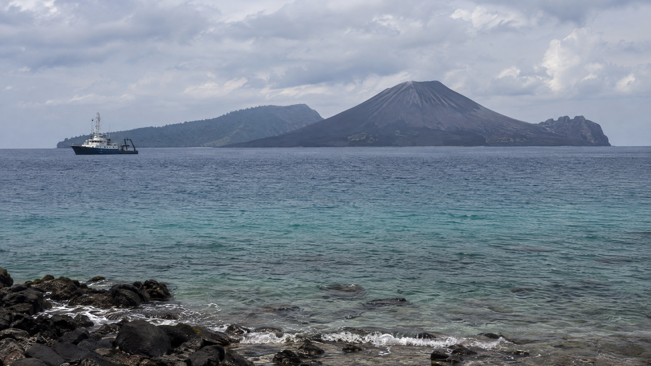
Caldera means a large volcanic depression formed when a magma chamber is emptied and the overlying structure collapses. Anak Krakatau, or “child of Krakatau”, began emerging in the 1920s within the 1883 caldera. The name describes its geological setting, not a separate hazard category.
Badan Geologi’s 5 September 2026 report says low-scale eruptions continued after the 22 December 2018 eruption until 16 December 2023, before activity resumed on 2 July 2026. The 2018 event is an important modern comparison: a partial collapse of Anak Krakatau’s flank, associated with eruption and instability, generated a tsunami that struck Banten and Lampung. It was not a repeat of the 1883 eruption, but it demonstrated that volcanic processes can create coastal waves without a large tectonic earthquake.
What did monitoring record during the 2026 activity?
During the 2026 episode, Badan Geologi used visual observations, CCTV, seismic counts, real-time seismic amplitude measurements (RSAM) and tiltmeters that track ground deformation. Its 7 September bulletin recorded a 25-hour continuous eruption from 4 September at 23:07 WIB to 6 September at 00:04 WIB, followed by Strombolian eruptions. It identified lava, incandescent rock, heavy ash and possible pyroclastic hazards, and set a 3-kilometre exclusion radius at that time.
The 21 September evaluation reported 224 eruptions through 3 September, a decline in activity and deflation, then changed the status from Level III (Siaga) to Level II (Waspada) at 18:30 WIB. The recommendation became a 2-kilometre no-entry radius, with warnings about incandescent ejecta and heavy ash. The volcano is administratively in South Lampung, but observations are made from posts in Kalianda and Pasauran, Serang, Banten.
BMKG added a separate layer of protection. In its 6 September report, the agency said 20 tsunami gauges around the Sunda Strait showed no sea-level anomaly up to 07:00 WIB. Its HF radar observations near Carita and Tanjung Lesung placed tsunami probability below 40 percent at that time, while satellite analysis tracked ash reaching aviation-relevant altitudes. These were time-specific findings, not a permanent guarantee that future activity cannot affect the sea.
What we know and what remains unclear
What we know: the 1883 disaster combined explosive eruption, structural collapse and tsunami; Anak Krakatau occupies the same caldera; the 2018 and 2026 episodes show continuing volcanic activity; and Indonesia now combines volcano observations with sea-level, radar, satellite and aviation data.
What remains unclear: historical observers did not have today’s dense sensor network, so estimates of volume, wave height and the precise timing and contribution of each process cannot be resolved to modern precision. For the present, no October 2026 status bulletin was verified in the sources used here. The latest located official notice is dated 21 September and says Level II remains in force until a subsequent evaluation. Residents and visitors should therefore rely on the latest Badan Geologi, BMKG and local BPBD notices rather than treating the 1883 record as a prediction of a repeat event.
Sources
- https://www.esdm.go.id/id/media-center/arsip-berita/peringati-140-tahun-letusan-g-krakatau-mitigasi-bencana-geologi-sebuah-keharusan
- https://www.usgs.gov/publications/krakatau-1883
- https://www.ncei.noaa.gov/news/day-historic-krakatau-eruption-1883
- https://geologi.esdm.go.id/media-center/fenomena-erupsi-menerus-gunungapi-anak-krakatau-tanggal-5-september-2026
- https://geologi.esdm.go.id/media-center/perkembangan-erupsi-gunungapi-anak-krakatau-tanggal-7-september-2026
- https://geologi.esdm.go.id/media-center/laporan-khusus-penurunan-tingkat-aktivitas-gunungapi-anak-krakatau-provinsi-lampung-dari-level-iii-siaga-menjadi-level-ii-waspada-tanggal-21-september-2026-pukul-18-30-wib
- https://www.bmkg.go.id/siaran-pers/bmkg-terus-pantau-dampak-erupsi-gunung-anak-krakatau